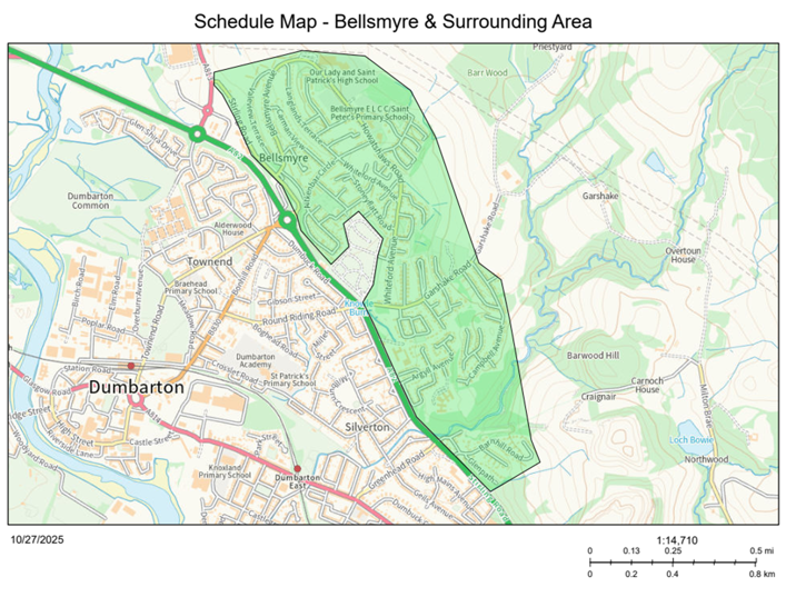
Bellsmyre and surrounding area 20mph Speed Limit Order
West Dunbartonshire Council Road Traffic Regulation Act 1984
The West Dunbartonshire Council, in accordance with their powers under section 84 of the Road Traffic Regulation Act 1984 and all other enabling powers, propose to consider the introduction of a 20-mph speed limit on the entire length or part of the length of those roads in Bellsmyre and Surrounding Area listed in the Schedule.
Full details of this proposal, which forms the proposed West Dunbartonshire Council (Bellsmyre and Surrounding Area) (20mph Speed Limit) Order, together with a plan and statement of reasons for proposing to make this Order, are available for inspection without payment of fee below and at West Dunbartonshire Council HQ, 16 Church Street, Dumbarton, G82 1QL.
Any person wishing to object to the proposal or make any other representations in relation to the proposal should send details of the grounds for their representation in writing to Christopher Anderson (Principal Solicitor – Section Head) at Municipal Buildings, College Street, Dumbarton G82 1NR or E-mail: Christopher.Anderson@west-dunbarton.gov.uk by 4pm on Monday 22 December 2025.
It is considered necessary to make the above-named Order to:
- Reduce vehicle speeds and enhance road safety for all users within West Dunbartonshire, particularly pedestrians and cyclists
- Support active travel
- Reduce the severity and likelihood of collisions
The proposed speed limit aligns with Scottish Government’s National 20mph Strategy.
Order
West Dunbartonshire Council in exercise of the powers conferred on them by Section 84(1)(a) of the Road Traffic Regulation Act 1984 (which Act of 1984 is herein referred to as “the said Act”) and all other powers enabling them in that behalf and after consultation with the Chief Constable in accordance with Part 111 of Schedule 9 to the Act hereby make the following Order:
- This Order may be cited as West Dunbartonshire Council (Bellsmyre and Surrounding Area) (20mph Speed Limit) Order and shall come into operation on the [DATE].
- The Interpretation Act 1978 shall apply for the interpretation of this Order as it applies for the interpretation of an Act of Parliament.
- No person shall drive a motor vehicle on any lengths of roads specified in the Schedule to this Order at a speed exceeding 20 miles per hour.
- The Order will apply only when such a restriction is identified as applying to that road by means of the display of appropriate traffic signs as prescribed by the Traffic Signs Regulations and General Directions (TSRGD) 2016.
- This Order shall have effect subject to the following variations of existing orders:
The provisions of any existing orders affecting any lengths of roads specified in the Schedule to this Order whether made or having effect as if made under the Road Traffic Regulation Act 1984, as amended, or under any other enactment are hereby varied to the extent that the provisions are inconsistent with this Order.
SIGNED at WEST DUNBARTONSHIRE on the X day of X TWO THOUSAND AND TWENTY FIVE.
Chief Officer
Roads and Neighbourhood Services
Council Offices
Church Street
Dumbarton
G82 1QL
Schedule
The effect of the Order is as follows:
No person shall drive or cause or permit any vehicle to be driven at a speed in excess of 20mph on the lengths of road in West Dunbartonshire specified in the table below.
| Name | Extent |
|---|---|
| Aitkenbar Circle | For its entire length |
| Aitkenbar Drive | For its entire length |
| Allan Crescent | For its entire length |
| Argyll Avenue | For its entire length |
| Argyll Place | For its entire length |
| Auchenreoch Avenue | For its entire length |
| Barnhill Road | For its entire length |
| Barwood Hill | For its entire length |
| Bellsmyre Avenue | For its entire length |
| Brackenhurst Street | For its entire length |
| Braeside Drive | For its entire length |
| Broomhill Drive | For its entire length |
| Brown Avenue | For its entire length |
| Campbell Avenue | For its entire length |
| Campbell Drive | For its entire length |
| Campbell Terrace | For its entire length |
| Carman View | For its entire length |
| Crosslet Avenue | For its entire length |
| Fraser Avenue | For its entire length |
| Garshake Avenue | For its entire length |
| Garshake Road | For its entire length |
| Garshake Terrace | For its entire length |
| Garshake Row | For its entire length |
| Garshake Wynd | For its entire length |
| Glebe Park | For its entire length |
| Glenpath | For its entire length |
| Glenside Road | For its entire length |
| Hillfoot Avenue | For its entire length |
| Howatshaws Road | For its entire length |
| Hunters Avenue | For its entire length |
| Langlands Terrace | For its entire length |
| Loaninghead Drive | For its entire length |
| Lomond Drive | For its entire length |
| Lomondgate Drive | For its entire length |
| Long Crags View | For its entire length |
| Macphie Road | For its entire length |
| Mansewood Drive | For its entire length |
| Maryland Road | For its entire length |
| McGregor Drive | For its entire length |
| McLeod Road | For its entire length |
| Merkins Avenue | For its entire length |
| Muir Road | For its entire length |
| Murray Place | For its entire length |
| Murroch Avenue | For its entire length |
| Penniecroft Avenue | For its entire length |
| Pinewood Court | For its entire length |
| St Andrew's Brae | For its entire length |
| St Andrew's Crescent | For its entire length |
| Stirling Road | From its extended kerbline with A82 (Barloan Toll Roundabout) in a general north-westerly direction for a distance of 815 metres or thereby. |
| Stoneyflatt Avenue | For its entire length |
| Stoneyflatt Court | For its entire length |
| Stoneyflatt Gardens | For its entire length |
| Stoneyflatt Road | For its entire length |
| Strowans Well Road | For its entire length |
| Stuart Road | For its entire length |
| Sutherland Drive | For its entire length |
| Valeview Terrace | For its entire length |
| Whiteford Avenue | For its entire length |
| Whiteford Crescent | For its entire length |
| Whiteford Gardens | For its entire length |
| Whiteford Place | For its entire length |
Schedule Map