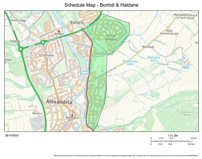
Bonhill and Haldane 20mph Speed Limit Order
West Dunbartonshire Council Road Traffic Regulation Act 1984
The West Dunbartonshire Council, in accordance with their powers under section 84 of the Road Traffic Regulation Act 1984 and all other enabling powers, propose to consider the introduction of a 20-mph speed limit on the entire length or part of the length of those roads in Bonhill and haldane listed in the Schedule below.
Full details of this proposal, which forms the proposed West Dunbartonshire Council (Bonhill and Haldane) (20mph Speed Limit) Order, together with a plan and statement of reasons for proposing to make this Order, are available for inspection without payment of fee below and at West Dunbartonshire Council HQ, 16 Church Street, Dumbarton, G82 1QL
Any person wishing to object to the proposal or make any other representations in relation to the proposal should send details of the grounds for their representation in writing to Christopher Anderson (Principal Solicitor – Section Head) at Municipal Buildings, College Street, Dumbarton G82 1NR or E-mail: Christopher.Anderson@west-dunbarton.gov.uk by 4pm on Monday 22 December 2025.
It is considered necessary to make the above-named Order to:
- Reduce vehicle speeds and enhance road safety for all users within West Dunbartonshire, particularly pedestrians and cyclists
- Support active travel
- Reduce the severity and likelihood of collisions
The proposed speed limit aligns with Scottish Government’s National 20mph Strategy.
Order
West Dunbartonshire Council in exercise of the powers conferred on them by Section 84(1)(a) of the Road Traffic Regulation Act 1984 (which Act of 1984 is herein referred to as “the said Act”) and all other powers enabling them in that behalf and after consultation with the Chief Constable in accordance with Part 111 of Schedule 9 to the Act hereby make the following Order:
- This Order may be cited as West Dunbartonshire Council (Bonhill & Haldane) (20mph Speed Limit) Order 202[] and shall come into operation on the [DATE].
- The Interpretation Act 1978 shall apply for the interpretation of this Order as it applies for the interpretation of an Act of Parliament.
- No person shall drive a motor vehicle on any lengths of roads specified in the Schedule to this Order at a speed exceeding 20 miles per hour.
- The Order will apply only when such a restriction is identified as applying to that road by means of the display of appropriate traffic signs as prescribed by the Traffic Signs Regulations and General Directions (TSRGD) 2016.
- This Order shall have effect subject to the following variations of existing orders:
The provisions of any existing orders affecting any lengths of roads specified in the Schedule to this Order whether made or having effect as if made under the Road Traffic Regulation Act 1984, as amended, or under any other enactment are hereby varied to the extent that the provisions are inconsistent with this Order.
SIGNED at WEST DUNBARTONSHIRE on the X day of X TWO THOUSAND AND TWENTY FIVE.
Chief Officer
Roads and Neighbourhood Services
Council Offices
Church Street
Dumbarton
G82 1QL
Schedule
The effect of the Order is as follows:
No person shall drive or cause or permit any vehicle to be driven at a speed in excess of 20mph on the lengths of road in West Dunbartonshire specified in the table below.
| Name | Extent |
|---|---|
| Auchincarroch Road | For its entire length |
| Barton Avenue | For its entire length |
| Brooke Avenue | For its entire length |
| Brown Street | For its entire length |
| Buchanan Avenue | For its entire length |
| Buchanan Court | For its entire length |
| Burn Street Lane | For its entire length |
| Burn Street | For its entire length |
| Cables Drive | For its entire length |
| Carmona Drive | For its entire length |
| Cook Road | For its entire length |
| Craiglynn Gardens | For its entire length |
| Dalmonach Road | For its entire length |
| Davidson Road | For its entire length |
| Dumbain Crescent | For its entire length |
| Dumbain Road | For its entire length |
| Elmbank Drive | For its entire length |
| First Avenue | For its entire length |
| Glen Avenue | For its entire length |
| Golfhill Drive | For its entire length |
| Haldane Terrace | For its entire length |
| Hall Street | For its entire length |
| Hillbank Street | For its entire length |
| Levenbank Terrace | For its entire length |
| Lindsay Quadrant | For its entire length |
| Manse Drive | For its entire length |
| Martin Avenue | For its entire length |
| McFarlane Road | For its entire length |
| McGregor Avenue | For its entire length |
| McInnes Street | For its entire length |
| McKinlay Avenue | For its entire length |
| Miller Road | For its entire length |
| Napierston Road | For its entire length |
| Northfield Drive | For its entire length |
| Northfield Road | For its entire length |
| Oakburn Gardens | For its entire length |
| Oakburn Walk | For its entire length |
| Oakfield Drive | For its entire length |
| Peters Avenue | For its entire length |
| Roy Young Avenue | For its entire length |
| Sandbank Crescent | For its entire length |
| Second Avenue | For its entire length |
| Shandon Brae | For its entire length |
| Shandon Crescent | For its entire length |
| Shearer Quadrant | For its entire length |
| Simpson Quadrant | For its entire length |
| Steadings Drive | For its entire length |
| Steele Crescent | For its entire length |
| Steele Walk | For its entire length |
| Talbot Road | For its entire length |
| Third Avenue | For its entire length |
| Union Street | For its entire length |
| Union Street Lane | For its entire length |
| Woodburn Avenue | For its entire length |
| Woodside Crescent | For its entire length |
Schedule Map